Big US cities are sinking. This map shows where the problem is the worst.
Big US cities are sinking. This map shows where the problem is the worst.

www.usatoday.com
Big US cities are sinking. This map shows where the problem is the worst.

Big US cities are sinking. This map shows where the problem is the worst.
Big US cities are sinking. This map shows where the problem is the worst.
The nation's fastest-sinking city is Houston, with more than 40% of its area dropping more than 5 millimeters (about 1/5 inch) per year, and 12% sinking at twice that rate.
kagis
https://texaslivingwaters.org/groundwater/subsidence-houston-galveston-region/
Understanding subsidence in the Houston-Galveston region
Since 1836, groundwater withdrawals have caused about 3,200 square miles of the Houston-Galveston area to subside (or sink) more than a foot, with some areas subsiding as much as 12 to 13 feet.
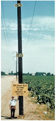
Noob-tier numbers, Texas. Here's a photo from 1977 in California showing land subsidence on a telephone pole from 1925 to 1977.
My brain isn't working? The pole was installed and ground receded 9 meters over the years? How far into the ground was the pole driven in the beginning?
The pole is just an ordinary pole. In 1977, after measuring land subsidence over time, they put the signs up on it to illustrate how far the land had sunk. They could have put the signs on anything tall enough to provide enough space.
Yeah that makes way more sense... thanks
No, here's the caption.
Figure 2. Approximate location of maximum subsidence in the United States identified by research efforts of Dr. Joseph F. Poland (pictured). Signs on pole show approximate altitude of land surface in 1925, 1955, and 1977. The site is in the San Joaquin Valley southwest of Mendota, California.
Link is here
https://water.usgs.gov/ogw/pubs/fs00165/
It uses the word 'aquitards' which is what my partner will undoubtedly be calling me when I go swimming
I'll never remember that word when I need it the most :(