[Aug 26] Update: Invest AL93 is now Tropical Depression 10
[Aug 26] Update: Invest AL93 is now Tropical Depression 10
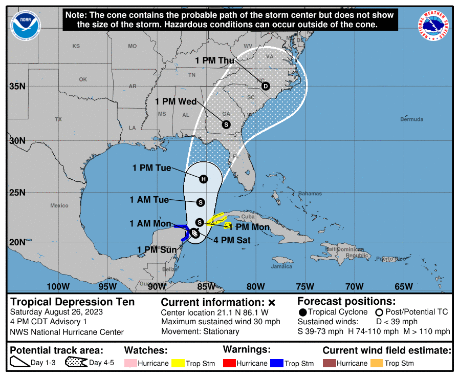
Tropical Depression Ten Discussion Number 1
NWS National Hurricane Center Miami FL AL102023
400 PM CDT Sat Aug 26 2023
The cloud pattern of the low pressure area located near the northeastern Yucatan Peninsula of Mexico has gradually become better organized today. Radar observations show a circulation has developed, although surface observations indicate that the western semicircle of this circulation is rather weak at this time. Given the increased organization, advisories are being initiated on Tropical Depression Ten. Surface synoptic observations suggest that the current intensity is around 25 kt.
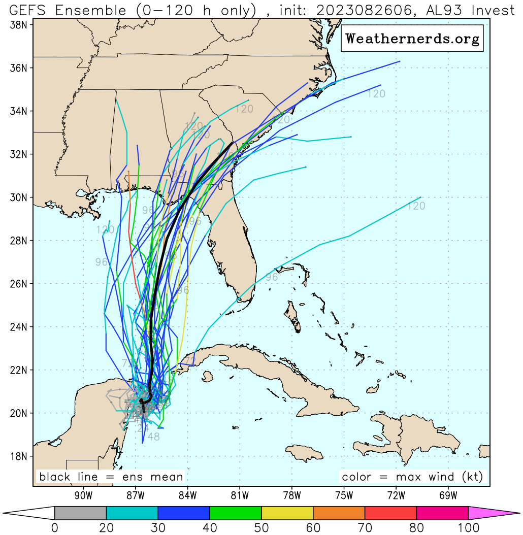
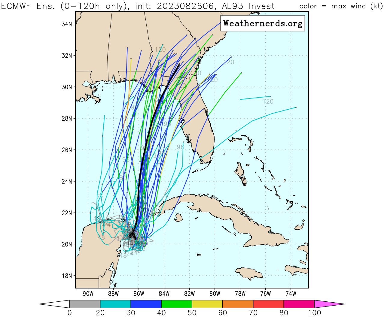
The current motion estimate is nearly stationary. There is a weakness in the subtropical ridge to the north of the tropical cyclone, leaving the system in a region of very weak steering flow. The dynamical guidance indicates that the system will remain in weak steering currents for the next 24 to 36 hours, so very little motion is predicted during that period. After that time, a mid-level ridge begins to build to the east of the tropical cyclone. This should cause a generally northward motion in the next 2 to 3 days. Then, a gradual turn to the north-northeast is expected as the system moves along the northwestern periphery of the ridge. The official track forecast is a blend of the simple and corrected dynamical model consensus guidance.
The tropical cyclone will be moving over very warm waters with only moderate vertical wind shear anticipated during the next several days. Therefore, gradual strengthening is forecast. The official forecast is similar to the latest LGEM guidance and shows the system becoming a hurricane over the eastern Gulf of Mexico. Users are reminded that there is significant uncertainty in 3-4 day intensity predictions and are urged to monitor changes to future forecasts.
KEY MESSAGES:
-
Heavy rainfall from Tropical Depression Ten is expected across the eastern Yucatan Peninsula and western Cuba. The heavy rainfall may produce areas of flash and urban flooding, as well as landslides, across western Cuba. The depression is forecast to become a tropical storm by Sunday, and tropical storm conditions are expected over portions of the Yucatan Peninsula where a Tropical Storm Warning is in effect. Tropical storm conditions are possible over portions of western Cuba within the Tropical Storm Watch area.
-
The depression is forecast to strengthen during the next few days and could become a hurricane over the eastern Gulf of Mexico, bringing a potential of dangerous storm surge, heavy rainfall, and strong winds to portions of the west coast of Florida and the Florida Panhandle by the middle of next week. Heavy rainfall is also likely to spread into portions of the Southeast U.S. by mid to late next week. Although it is too soon to specify the exact location and magnitude of these impacts, residents in these areas should monitor updates to the forecast of this system and ensure that they have their hurricane plan in place.
FORECAST POSITIONS AND MAX WINDS
INIT  26/2100Z 21.1N  86.1W   25 KT  30 MPH
 12H  27/0600Z 21.0N  86.3W   30 KT  35 MPH
 24H  27/1800Z 20.9N  86.2W   35 KT  40 MPH
 36H  28/0600Z 20.8N  86.1W   40 KT  45 MPH
 48H  28/1800Z 22.0N  85.7W   45 KT  50 MPH
 60H  29/0600Z 24.0N  85.6W   50 KT  60 MPH
 72H  29/1800Z 26.3N  85.3W   65 KT  75 MPH
 96H  30/1800Z 31.5N  83.0W   45 KT  50 MPH...INLAND
120H  31/1800Z 35.0N  79.0W   30 KT  35 MPH...INLAND
$$
Forecaster Pasch
Original Post:
(800 AM EDT Sat Aug 26 2023) Northwestern Caribbean Sea and Eastern Gulf of Mexico (AL93): Shower and thunderstorm activity continues to show signs of organization in association with an area of low pressure located near the Yucatan Channel. Environmental conditions appear conducive for further development of this system, and a tropical depression is likely to form within the next day or two while it moves generally northward over the southeastern Gulf of Mexico. Interests in the Yucatan Peninsula of Mexico, western Cuba, and Florida should monitor the progress of this system.
- Formation chance through 48 hours...high...70 percent.
- Formation chance through 7 days...high...90 percent.
(1205 UTC Sat Aug 26 2023) Invest AL93: Shower and thunderstorm activity continues to show signs of organization in association with an area of low pressure (invest AL93) over the northwestern Caribbean Sea. Scattered moderate convection is noted within 120 nm in the N semicircle and 60 nm in the S semicircle of the low. Current winds are 20 kt with seas of around 5 ft. Environmental conditions appear conducive for further development of this system during the next several days, and a tropical depression is likely to form late this weekend or early next week while it moves generally northward over the eastern Gulf of Mexico. Interests in the Yucatan Peninsula of Mexico, western Cuba, and Florida should monitor the progress of this system. Please refer to the latest NHC Tropical Weather Outlook at www.hurricanes.gov for more details.