Satellite mapping reveals extensive industrial activity at sea - Nature
Satellite mapping reveals extensive industrial activity at sea - Nature
www.nature.com Satellite mapping reveals extensive industrial activity at sea - Nature
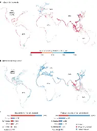
Satellite imagery, vessel GPS data and deep-learning models are used to map industrial fishing vessel activities missing from public tracking systems and changes in offshore energy infrastructure in the world’s coastal waters during 2017–2021.
0
comments