Satellite images reveal China built a replica of Taipei’s presidential district in remote Inner Mongolia, fuelling speculation that Beijing uses the site as training ground for an invasion of Taiwan
Satellite images verified by FRANCE 24 reveal that China has built a replica of Taipei’s presidential district in remote Inner Mongolia, fuelling speculation that Beijing intends to use the site as a…
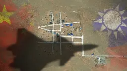
The satellite images reveal a layout of streets strongly resembling the Bo’ai Special Zone, a restricted area in Taipei’s Zhongzheng District that houses Taiwan’s most important state buildings, including the presidential palace, the supreme court, the ministry of justice and the central bank of Taiwan.
The Bo’ai Special Zone is subject to specific regulations, including a strict ban on overflight.
This should come as no surprise. The UK's MOD did similar, albeit on a smaller scale, for training troops for deployment in Northern Ireland, and Germany/Europe.
I think we all know China is gearing up to attack Taiwan as they make no secret that, as far as they are concerned, it belongs to them. The fact that the Taiwanese don't agree is neither here nor there.
The UK’s MOD did similar, albeit on a smaller scale, for training troops for deployment in Northern Ireland, and Germany/Europe.
Those are and were not their enemies and they were not specific targets. What is so eyebrow-raising here is that it is so specific.
The fact that the Taiwanese don’t agree is neither here nor there.
Uhmm yeah that really does make the difference between an invasion and an amicable unification. I would say what China things is neither here nor there because they don't own it so they have nothing to say about it.
You're reading that last bit out of context. As* far as the Chinese are concerned, *what the Taiwanese think is neither here nor there. The Chinese have decided its theirs. Nobody else gets a say.
Training yes I'm sure. Training of a specific target? I don't think so. It only makes sense if you're really planning to attack that target, which is what makes this shocking. Does America have a mockup Kremlin?
The US, and pretty much everyone, regularly runs "war games" with potential scenarios of real targets. That definitely includes the Kremlin, and other targets from all around the world, it would be naive to think otherwise.
But... simulators have been a thing for some time already, which is why I'm asking. I haven't been to the ones they've built, like:
Satellite photos are high resolution, capturing large areas at a time, which means stuff off-center is not captured perfectly orthogonal. Not sure you could tell between a satellite, high altitude balloon, or U-2 photo, just from a cropped piece of it.