Map Enthusiasts
- Vintage Map of Greater Los Angeles 1932

cross-posted from: https://lemm.ee/post/47534442
> cross-posted from: https://lemmy.world/post/22092605
- Handedness of rail traffic: left hand and right hand operation world wide.

Not visible in the map, but interesting to note, is that in France the trains normally drive on the left, except in Alsace where they drive on the right as a legacy of the time the province belonged to Germany.
- The EIU's 2023/24 democracy index

https://www.eiu.com/n/democracy-index-conflict-and-polarisation-drive-a-new-low-for-global-democracy/
- A map of Aravalli, one of the oldest mountain chains in the world (1.8 billion years) - Perrin Remonte

https://www.perrinremonte.com/fraccueil-1
- Europe divided into regions of 1 million people

cross-posted from: https://discuss.tchncs.de/post/24398649
> Credits: https://old.reddit.com/r/dataisbeautiful/comments/1gefa5y/europe_divided_into_regions_of_1_million_people_oc/
- Word for Thursday in European Languages

Source: https://commons.wikimedia.org/wiki/File:Word_for_Thursday_in_European_Languages.svg
- Driving/Driver('s) Licence/License

> In English, the name of document that entitles someone to drive a vehicle differs, with around generally 6 permutations. Driving/Driver/Driver’s and licence/license.
> As a noun, “licence” is generally how you would spell the verb using British English, whereas in American English the noun is spelled the same as the verb; “license”.
> Driving vs. “Driver’s” is more subjective in my opinion. It is an authorisation for the act of driving, so it being a “Driving” licence/license is logical. As the same time, the document is in the possession of the driver, so “Driver’s” is also equally as valid. A handful of countries use “Drivers”, which is just sloppy, as it doesn’t make any grammatical sense.
> I tried my best to compile data on all countries which mention the document in English. In Australia, Canada and the US, licences are issued by state/territory, so I’ve included their differences.
> I only included countries for which an English version of the name is on the actual licence. On many EU licences, the English is written very faintly on backgrounds. For many smaller countries I couldn’t find examples of the document. In South America, ‘Licencia de conducir” was most common, but a few permutations in Spanish. On the African continent, the French “Permis de conduire” was also fairly common. Multi-language licences with English, French and other languages was also common. I only picked out the English translation for this map.
> In my subjective opinion, "Driving licence" feels most right; but as this map illustrates, it’s a diverse interpretation. For licence/license, the difference between C/S is almost indistinguishable in a small font and in spoken word. Some evident US/UK influence on the map.
https://old.reddit.com/r/MapPorn/comments/1fvftxw/drivingdrivers_licencelicense_oc/
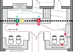
- How to Design an Iconic NY Fast Food Joint - DesignObserverdesignobserver.com How to Design an Iconic NY Fast Food Joint - DesignObserver
Design secrets of New York fast food icons.

- Mapa of the train services of Catalunya (from !barcelona@lemm.ee)

You might not see it if you have specific languages selected and not catalan
cross-posted from: https://lemm.ee/post/44181347
> Source: https://old.reddit.com/r/catalunya/comments/1fwo5nn/he_fet_un_mapa_dels_serveis_ferroviaris_de/
- Map of the Chagos Archipelago, constituting the British Indian Ocean Territory. UK has just announced that it will hand over sovereignty to the islands to Mauritius.

Source on UK ceding the islands to Mauritius
Wikipedia article on Chagos Archipelago
Another map displaying the main islands zoomed in.
- The Typical American Lives Only 18 Miles From Mom

Edit: source with some more info
https://www.nytimes.com/interactive/2015/12/24/upshot/24up-family.html
- TIL about Sebastian Münster's 1540 map of the Americas, the first one to show that North and South America were connected by an isthmus and the first to call it 'The New World.'

cross-posted from: https://lemmy.world/post/19568259
> More info here: https://exhibits.stanford.edu/ruderman/catalog/mz230kn1495
- How Smooth Is The Earth, Really? Explore Elevation With An Interactive 3D Globe

https://perthirtysix.com/tool/earth-smoothness
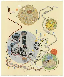
- Mapping Cinematic Pathskottke.org Mapping Cinematic Paths
Artist and illustrator Andrew DeGraff makes maps that show where the characters travel during movies — imagine Billy’s

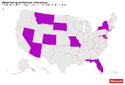
- Map Shows States That Will Vote on Abortion Rights in November - Newsweekwww.newsweek.com Map shows states that will vote on abortion rights in November
November ballots will include questions related to abortion rights in nine states, including two battlegrounds.

cross-posted from: https://lemmy.world/post/18917159 > These are the states that will put the question to their voters in November.
- North American English Dialects, Based on Pronunciation Patterns

Source: https://aschmann.net/AmEng/#Au_Washington_State
- Global population density

Another website: http://www.luminocity3d.org/WorldPopDen/#6/37.545/16.556
Source: https://ourworldindata.org/grapher/population-density
- Egypt's High Speed Rail Network

1st segment is under construction with completion date of 2027. 2nd segment has been extended to the Western Desert and has begun construction, with no announced end date. Construction of the 3rd segment, which is currently in the planning stage, is reported to begin soon. Further lines are proposed


