
OpenStreetMap community
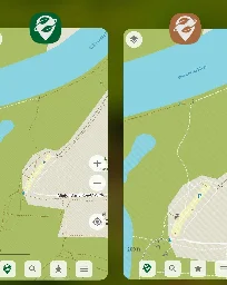
- The May 2024 Organic Maps update with bookmarks and tracks sorting by name, better paved/unpaved paths colors, GPX import fixes, drive-thorough, and many other changesorganicmaps.app The May 2024 Organic Maps update with bookmarks and tracks sorting by name, better paved/unpaved paths colors, GPX import fixes, drive-thorough, and many other changes
The May 2024 Organic Maps update (get it here) supports bookmarks and tracks sorting by name, paved paths are white, and unpaved ones are brown. And there are s…
- Pokémon Go Players Altering OSMarstechnica.com Pokémon Go players are altering public map data to catch rare Pokémon
OpenStreetMap contributors have been dealing with Pokémon Go players for years.

People are editing OSM to be able to get their Pokémon and others are changing OSM to mess with people so they can't get them
- We are bringing to #Wikimedia East, Southeast Asia & Pacific (ESEAP) 2024! 🗺️✈️🌏🇲🇾
We are bringing @openstreetmap to #Wikimedia East, Southeast Asia & Pacific (ESEAP) 2024! 🗺️✈️🌏🇲🇾
Join us on Sunday, 12 May, 11AM at Mahua 1 Room to learn how to map in #openstreetmap + link #wikidata!
Full program here: https://meta.wikimedia.org/wiki/ESEAP\_Conference\_2024/Programme
\#eseapconference2024 #ESEAP #ESEAP2024 #ESEAPKK24 #WikimediaESEAP #WikimediaESEAP2024 @seav @Supaplex
- How to map prepared and planned bus stops that are not in use yet?
Recently the city redesigned the street and prepared at least 4 bus stops. The stops all have the road markings and tactile paving, etc. but no bus stop signs yet and currently no line stops there. (There is an ongoing reorganization of bus lines in my area.)
The wiki page describes how to map a bus stop and I can follow along. Everything except the line(s) and the names is local knowledge.
How should those be mapped (if at all)? Map what’s known already and add
construction:bus_stop? - OSM knows where my solar panels are
I have a solar array on my roof. If I find my house in OSM, there's a lightning bolt icon indicating there's a solar array present. Not only that, but the exact layout of the panels in my roof is shown. I never submitted this info to anyone, Google Maps Satellite view doesn't show them. I'm really curious where OSM got such detailed data.
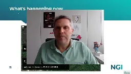
- Maurizio Napolitano on the importance of OSM in the world of digital commonstube.network.europa.eu NGI Talk - Maurizio Napolitano - OpenStreetMap: A collaborative Ecosystem Serving Society & Business
In today's interconnected world, accurate geographic information is crucial for various applications, from urban planning to logistics. OpenStreetMap (OSM) stands out as a solution, offering a collaborative mapping platform that democratises access to geospatial information. Led by Maurizio Napolita...
- Beware of Fake Beachescommunity.openstreetmap.org Beware of fake beaches (Pokémon Go)
Five days ago Niantic announced a new Pokémon in Pokémon Go, which spawns only in beaches. So it could happen that someone could add fake beaches in these days (I found two users already in Italy with a quick check), this is just a reminder to take a look in you local area. One method could be to fi...
Overpass Query:
//courtesy of WoodWoseWulf on Discord [timeout:240] [bbox:{{bbox}}]; ( way[natural=beach](newer:"2024-04-23T00:00:00Z"); ); out body; >; out skel qt;post has been crossposted since the original did not federate correctly with lemmy.ml
- Release v57.3 · streetcomplete/StreetCompletegithub.com Release v57.3 · streetcomplete/StreetComplete
Fix UNDO: It didn't actually do anything for edits that were already synced! This critical issue existed since v57.2 (#5600, #5602) Traffic signals: Improve wording (#5591) Max speed: Show warning ...

StreetComplete is an easy to use editor of OpenStreetMap data available for Android. It can be used without any OpenStreetMap-specific knowledge. It asks simple questions, with answers directly used to edit and improve OpenStreetMap data. The app is aimed at users who do not know anything about OSM tagging schemes but still want to contribute to OpenStreetMap.
- GraphHopper Routing Engine 9.0 Released - GraphHopper Directions APIwww.graphhopper.com GraphHopper Routing Engine 9.0 Released - GraphHopper Directions API
We have released version 9.0 of GraphHopper, the flexible and fast open source routing engine for OpenStreetMap. Read more about it on GitHub, try GraphHopper Maps and read on to find out what’s new. The following contributors worked on over 40 pull requests and many more smaller changes: easbar, ka...
- GOwin's Diary | A more inclusive mapping party setup, for same-day imagery collection and mapathons. | OpenStreetMapwww.openstreetmap.org GOwin's Diary | A more inclusive mapping party setup, for same-day imagery collection and mapathons. | OpenStreetMap
OpenStreetMap is a map of the world, created by people like you and free to use under an open license.
- MapSCII - OSM console renderergithub.com GitHub - rastapasta/mapscii: 🗺 MapSCII is a Braille & ASCII world map renderer for your console - enter => telnet mapscii.me <= on Mac (brew install telnet) and Linux, connect with PuTTY on Windows
🗺 MapSCII is a Braille & ASCII world map renderer for your console - enter => telnet mapscii.me <= on Mac (brew install telnet) and Linux, connect with PuTTY on Windows - rastapasta/mapscii

To connect simply run:
shell telnet mapscii.me - Is there a way to see how many amenity=bench I have created?
I wonder how many I have already mapped.
- Using OpenStreetMap to play the game in any locationstore.steampowered.com Save 10% on Infection Free Zone on Steam
Choose any real region from the world. Choose your base of operations, then rebuild and readapt the buildings around you to create a self-sustaining settlement. Take charge of a group of survivors from your city. And when the night falls - Defend the zone from the infected!
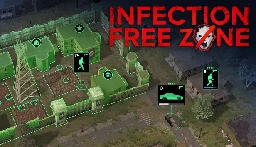
Pretty cool idea by using open street maps you can download the location you want and play the game there, defend your neighborhood or loot your house.
The reviews seem decent but mention it needs a lot of tweaking as it just released on early access, like water not affecting where zombies can walk or elevation not being a thing.
Maybe this can get some more people interested in mapping
- Ordnance Survey now publishes its data in OpenStreetMap format
> 2004: OpenStreetMap is founded because Ordnance Survey won’t make their data open > > 2024: Ordnance Survey now publishes its data in OpenStreetMap format because that’s what people expect
-- Richard Fairhurst @richardf
- osm2gmaps
Convert your OpenStreetMap-based application links into Google Maps, Apple Maps or other links (and vice versa) without having to use proprietary software!
osm2gmaps converts links from applications like Organic Maps or OSMand to proprietary maps links, like Google Maps or Apple Maps. Just copy the link and share it to osm2gmaps or copy and paste it inside the app, it will automatically convert the link to your chosen type and copy it to the clipboard.
- Unmapped USA - Mastodon Bot
I thought I’d share this Mastodon bot - @SmallTownUSA - here as I’ve found it great fun.
> Posting towns in the USA with a population less than 1000 that are undermapped on OpenStreetMap.org
I quite enjoy mapping areas that have nothing or very little mapped. This bot kind of helps with that. Although, I’d love another one for my home country and current country of residence.
- Sharing recorded tracks / imagery for someone else to turn into data?
I've found that I still record a lot of data while hiking. Trail surfaces, POIs, you name it. However I find less and less time to turn these datasets into actual map data. I can't be the only one that this happens to. Is there some kind of service that connects people that collect data and armchair mappers?
- How to use different Nominatim on web openstreetmap
I would like to use openstreetmap as replacement for google maps (on web) However default nominatim doesn't generally give correct address (when searched for POI). Is there way to change nominatim provider?
- Install Organic Maps on Linux | Flathub

Organic Maps is available on Linux! It's on flatpak and several package repos (but not apt). I don't know how long it's been there — I just discovered it.
The splash screen cautions that this Linux beta doesn't have parity with the mobile apps yet, but it's still a huge leap over Gnome Maps. Vector rendering, so you can zoom in as far as you want, and free / open source / not shitty (notwithstanding the big scary EULA, which just contains all the OSS licenses for all the pieces).
- Why do maps that use OSM as a backend have more detail that OSM?
Where is it coming from? Are there other open sources of map data?
I've seen multiple mapping websites that provide business solutions that seemed to be sourcing their data from OSM. However, when I zoom in to known problem areas, I find a lot more detail. They're not getting it from Google, Bing, or Apple, and I find it implausible that these small specialized companies are sinking tens of thousands of hours into adding fine map detail. So where are they getting it? If it is open source is there a way to merge it back into OSM?
For example this website, maptiler, cites open street map as their source. Compare it with the official site. I have found multiple examples of the same thing. Can anyone explain to me what's going on here?
- Crowdworked mapping: more fun in #OpenStreetMap! 🗺️ 🫶
Crowdworked mapping: more fun in #OpenStreetMap! 🗺️ 🫶
Traveled back to my home court #UPLB to bring the great news of #opendata #foss4g to young leaders! Grateful for the opportunity 🙏🏼🙏🏼
thank you besh @dfeyeandal for coming with! New #youthmappers chapter, yeah? 😉✊🏼❤️🔥
- Rogue Editors Started a Competing Wikipedia That’s Only About Roads (gizmodo.com)gizmodo.com Rogue Editors Started a Competing Wikipedia That’s Only About Roads
A group of Wikipedia editors wrote 15,000 articles on US roads and highways. But after a fight over the platform's rules, they went rogue.
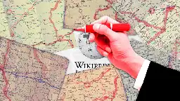
> https://wiki.aaroads.com/
- Practical advise for massive edits?
I live in an area where tons of data is missing. I mean the whole areas with no street addresses, missing streets, missing bike routes, etc.
Is there a guide or special tools for preparing to make massive edits like this? Is there a particular work flow that people use or resources? How do I even get started?
- Life360 Alternative with OpenStreetMap data?mastodon.social Governor Keagan (@governorkeagan@mastodon.social)
Does anyone know of an app similar to Life360 but uses #openstreetmap instead of #google or #apple map data?
I asked on Mastodon but no one seems to know so I thought I’d ask here as well.
I’m looking for an app that provides the same or similar functionality to Life360 but instead of using Google/Apple map data it uses OpenStreetMap data. Does this even exist?
- Join us this Saturday, 2 March for #OpenStreetMap Local Chapters and Communities Congress (LCCC) 2024!
Join us this Saturday, 2 March for #OpenStreetMap Local Chapters and Communities Congress (LCCC) 2024!
Let’s get together and discuss efforts to support &grow our mapping communities!
Register now & spread the word! 🗣️ https://tinyurl.com/osm-lccc24 #osmlccc24
See you! @openstreetmap@lemmy.ml @openstreetmap
- What's up with KartaView pushing Android app updates with no changes to their Github source code?
If you look at their Github account, there hasn't been a commit to their Android app in 3 years: https://github.com/kartaview/android
However, their Google Play listing shows it was last updated on February 8, 2024. https://play.google.com/store/apps/details?id=com.telenav.streetview
When Grab Holdings acquired KartaView, did they just take the open source code and start working on a proprietary copy? It's MIT licensed which allows commercial use.
- How do you add buildings when the map is crooked?
Sorry, crooked isn't the best word, but I can't think of a better one.
I'm still quite new to OSM, and I want to start adding the buildings in my town. When I open the edit option though, the map overlay is at an angle. It's not a massive amount, but it's enough that you can see one sometimes two sides of most buildings, so the roof isn't aligned straight down, if that makes sense?
I live near Aberdare in South Wales, and you can see that where someone has added some buildings in the town centre at some point, they're now not aligned with the map overlay:
https://www.openstreetmap.org/edit#map=20/51.71312/-3.44499
Do I draw around the roof that I can see on the map? Do I edit the existing buildings so that they line up with the overlay? I'm not sure what the best course of action is for something like this.
Thanks in advance :)
- How do you tag bus lanes?
https://taghistory.raifer.tech/#/bus%3Alanes/&/lanes%3Apsv/&/psv%3Alanes/&/lanes%3Abus/&***/busway/
- https://wiki.openstreetmap.org/wiki/Key:bus:lanes
- https://wiki.openstreetmap.org/wiki/Key:lanes:psv
- https://wiki.openstreetmap.org/wiki/Key:psv:lanes
- https://wiki.openstreetmap.org/wiki/Key:busway
I use
psv:lanes, but there are no real bus lanes here, it's called buslane, but law says taxis can also use it. - #shamelessplug 👀
my prolonged #OpenStreetMap diary about my experience as an OSMF board member. Apologies for the delay!
🪑🗺️community in the map and at the table: my first year and continuing plans as OSMF board member
- Planning route for electric vehicle?
Hello all!
Is there some app like OsmAnd that lets you plan a route for an electric vehicle? I really love OsmAnd, but as far as I can tell, it lacks the ability to set a destination and plan a route based on the vehicle's range and the available charging stations. It would also be nice if you could specify whether you want to use fast chargers or not. Most highways do have fast chargers, but it would be bad if the route led to a non-fast charger for longer trips.
- Wasn't there a project a while back to add local highway shield symbols to OpenStreetMap? What happened to that?
Still just plain rectangles with text.
- OSM Teams is a tool for creating teams and roles in the #OpenStreetMap ecosystem for management of groups and communities to organize around existing tools like Tasking Manager, OSMCha, or iD, and
OSM Teams is a tool for creating teams and roles in the #OpenStreetMap ecosystem for management of groups and communities to organize around existing tools like Tasking Manager, OSMCha, or iD, and improves collaboration.
\- Found or find a team: https://mapping.team/teams
\- Video demo: https://www.youtube.com/watch?v=GSa4IWxZz4g
- dpschep's Diary | Introducing Overpass Ultra v2 | OpenStreetMapwww.openstreetmap.org dpschep's Diary | Introducing Overpass Ultra v2 | OpenStreetMap
OpenStreetMap is a map of the world, created by people like you and free to use under an open license.

- Not clear yet what the concrete benefits are, but it’s worth noting #OpenStreetMap has been registered as a “Digital Public Good” by the Digital Public Goods Alliance (#DPGA), which is a
Not clear yet what the concrete benefits are, but it’s worth noting #OpenStreetMap has been registered as a “Digital Public Good” by the Digital Public Goods Alliance (#DPGA), which is a multi-stakeholder United Nations-endorsed initiative. https://blog.openstreetmap.org/2024/02/05/osm-named-as-a-digital-public-good-by-un-affiliated-agency/